
The Cilician Gates is a mountain pass in the Taurus mountains that connects the Cilician plain to the Anatolian plateau. In pre-Roman days, it was “the only wagon road that led across the Taurus and through the ages the most famous of the passes of Anatolia” (Magie, Roman Rule, 276). As Ramsay noted about the impressive ravine, “The Gates formed a great and strong defense, which strikes almost every traveller with admiration and awe” (“Great Taurus Pass,” 381). This post describes the geography and history of the Cilician Gates.
Geography
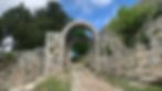
This picture is looking south through the Cilician Gates, with Gülek Castle in the distance, the modern road on the right, and the creek bed on the lower left.

The importance of the Cilician Gates stems from its geographical and political location. The Hellenistic Kingdoms and Roman Empire were centered on the Eastern Mediterranean. This region had three main areas, each with a famous capital: Egypt (Alexandria), Syria (Antioch), and Asia (Pergamon, Ephesus). In an era of great trade and communication, travel between these three regions was vital. Movement between Syria and Asia often occurred by sea; boats cabotaged along the south coast of Anatolia, as this was easier and cheaper. However, land travel was also common, especially in the winter months when the Mediterranean was too stormy (cf. Acts 27) or when people had to reach an inland destination. When people traveled by land between Syria and Asia, the mountainous geography of Anatolia forced most of them along a single route. Between the coastal plain of Cilicia and the plateau of Asia Minor, the route bottlenecks at one particular point. The vast majority of traffic across Anatolia has to pass through the Cilician Gates—a natural and narrow defile. Because of their strategic and defensible nature, the Cilician Gates were prominent throughout history.
Talbert’s map (“Asia Minor in the Second-Century C.E.”) shows the Cilician Gates (Kilikiai Pulai) where it is located in the Taurus Mountains, 40 km due north of Tarsus.

At an elevation of 1,000 meters, the passage was about 100 meters long. Vertical rock walls 30 meters tall stand on both sides of the creek (Gökoluk River). In antiquity, the natural towers provided an aerial view of traffic and a base for attacking any enemies trying to pass through. As Ramsay noted, “The position would have been impregnable, unless an enemy could cross the rocky ridge and come down in the rear of the defenders” (“The Great Taurus Pass,” 381).
The pass was famous in history. In a speech given in Rome, the Smyrnaean orator Aristides (2C CE) praised the Roman Empire for their road network. To illustrate the new level of security and ease of travel, he comments that people were no longer frightened by the Cilician Gates, as if his audience in Rome would understand that reference (Oration 26.100).
Xenophon mentions the pass was wide enough for a four-horse carriage, and Curtius says four soldiers could walk side-by-side through the pass. In that case, the road was about 3-4 meters wide. Older pictures show how narrow the pass originally was.

Marek, In the Land of a Thousand Gods, p. 380

Ramsay, “Cilicia, Tarsus, and the Great Taurus Pass,” p. 379.
This view from the creek bed shows that the modern highway is 15-20 meters above the creek. This means the original pass was almost twice as deep as it currently is.

After passing along the creek to the west side of the highway, this picture looks northeast through the pass and at the east wall.

History
Many historical events are associated with the Cilician Gates. Here is a list.
5C BCE—Herodotus stated that the Persian Royal Road passed through Cappadocia and “the boundary of Cilicia” (5.52). This suggests the route negotiated the Cilician Gates. However, Herodotus commented that the route crossed the Halys River twice, which suggests Herodotus was not well informed.
401 BCE—The Persian prince Cyrus revolted against his brother, the King of Persia. He marched with 10,000 Greek troops from Asia to Persia. According to Xenophon, the way to Cilicia “was a cart track which was so steep that no army could get through against the slightest opposition” (Anabasis/The Expedition of Cyrus 1.2.21–22). Cyrus’ men waited in the valley north of the Cilician Gates because of a rumor that the pass was guarded from its heights. Once the heights were abandoned, they passed through Tarsus.
333 BCE—Alexander marched his army through the pass uncontested, as the Persian Army was not occupying it. They proceeded down the valley to Tarsus, where Alexander swam in the Cyndus River as he awaited Darius’ forces.
51 BCE—The Roman governor Cicero traveled from Galatia to Cilicia to assume his one-year governorship in Tarsus.
39 BCE—The Roman general Publius Ventidius defeated the Parthian armies and their allies in the “Battle of the Cilician Gates.” According to Plutarch’s “Life of Anthony,” Ventidius was the first Roman general to receive a Roman Triumph (public victory parade) for defeating the Parthians.
50s CE—On their second and third missionary journeys, Paul and Barnabas departed from Syrian Antioch to revisit the churches in Galatia. Assuming they went by land, they likely passed through the Cilician Gates. Mark Fairchilds argues they instead went through Rough Cilicia up the Calycadnus (Göksu/Silifke) River valley because that region has Jewish tombs, and Paul prioritized visits to Jewish communities (Rom 1:16; Acts 13:46–47). This is possible, as Paul spent several years in Tarsus founding churches throughout Cilicia, but the travelogues in Acts note only the churches in Galatia. If Paul was intent on visiting Galatia, the fastest and safest route would be through the Cilician Gates.
117 CE—Hadrian passed through the Cilician Gates, as indicated by an itinerary inscription found in Rome.
175 CE—Roman Emperor Marcus Aurelius and his wife, Faustina the Younger, passed through. She died somewhere north of Podandos in a place renamed Colonia Faustiniana (modern Çiftehan or Başmakçı) in her honor.
194 CE—Septimus Severus passed through the Cilician Gates.
217 CE—The Roman Emperor Caracalla widened the pass and improved the Via Tauri road. This is known from the inscription in the gorge (discussed below) and from milestones found in Podandus (modern Pozanti). He renovated the road to better supply armies during his eastern campaign against the Persians. The battle did not end well, as Caracalla died in Carrhae the same year.
4/5 CC CE—As the Roman Empire restructured around its newfound Christian identity, a “Pilgrim’s Road” passed from Ankara through the Cilician Gates and into Syria. This facilitated Christian pilgrimage from Constantinople to Jerusalem.
7–11 CC—The pass functioned as the border between Arabs and Byzantines, so it was often made impassible by its being lodged with cut rock from above. The two armies attacked each other regularly, so it would have been cleared and made passable on many occasions.
12–13 CC—Crusaders passed through on their way to Antioch and Jerusalem. They called it the "Gate of Judas," for it was an enemy of their cause.
Early 1900s—German engineers built a narrow-gauged railway through the pass so that Ottoman sultans in Istanbul could move troops to their territories in the Arabian Peninsula.
1990s–The Turkish Republic constructed a six-lane highway (O-21) through the Cilician Gates.
Caracalla's Inscription

When Roman Emperor Caracalla renovated the pass and the corresponding road in 217 CE, he carved a small inscription onto the east wall inside the pass. The original location is visible in Marek’s picture above (1970s?). When Turkey widened the pass in the 1990s, it cut out a large piece of rock with the inscription. This fell to the creek bed, where it remains visible (at the bottom of the vertical picture).
The inscription reads: “The Emperor Caesar Marcus Aurelius Antoninus, the faithful, blessed, and invincible Augustus [Caracalla] made the road wider by cutting through the mountains.”
In 2020, treasure hunters bore two holes into the inscription (as if some treasure were hidden in the solid rock behind the inscription!). Caracalla’s milestones used to stand at a nearby gas station but have been removed, and we are not sure where they are located. I hoped to find them in the Tarsus Museum but did not.

Gülek Castle
Three kilometers south of the pass is Gülek Castle. From its peak at 1,600 meters, one looks down on the Cilician Gates and the entire route from Cappadocia to Cilicia. Byzantine and Arab forces used the natural vista, and the ruined castle dates to the Armenian Kingdom of Cilicia (twelfth and thirteenth centuries). A nice, single-lane asphalt road leads to the castle from the town of Gülek. The remains are sparse, but the vista is spectacular.

Conclusion
While it is regrettable that the modern Turkish highway has stripped and scarred the historic pass, context helps explain this decision. Since the time of Ataturk, the Turkish government has fought with Kurdish separatists in the southeast. Ankara has invested heavily in integrating the remote region with the rest of the country. This includes a six-lane expressway from Istanbul to Diyabakır. As a result of the new road, drivers can cross the entire country (1,500 km) in less than 15 hours without stopping at a single traffic light. This road has brought economic development to the long-impoverished southeast, and Turks from Istanbul and Izmir increasingly vacation in the southeast. The people of Turkey take great pride in this accomplishment.. President Erdoğan has often said, “Roads are life; roads are civilization.” This political context explains why Turkish authorities blasted open the Cilician gates for a six-lane highway. I lament it as a historian, but it has aided economic progress and political unity.
Although the highway runs through the pass, you can easily visit the site. From the 0-21, exit to the mountain town of Akçatekir. Once on the east side of the freeway, take a frontage road 4 km south to this point and park in the open lot. From there, concrete steps lead down to the creek bed. You can hop over the low railing to inspect the inscription, then walk along the stream bed as it passes through a tunnel under the highway. Besides the inscription, I could not find any other evidence, such as the roadbed of the historic route.
Further Resources
Ramsay, W. M. “Cilicia, Tarsus, and the Great Taurus Pass.” The Geographical Journal, vol. 22 (1903), pp. 357–410. Online here.
Harper, Richard P. “Podandus and the via Tauri.” Anatolian Studies, vol. 20 (1970), pp. 149–153. Online here.
Christol Michel, Drew-Bear Thomas. “L’aménagement de la Via Tauri sous les Sévères.” In Anatolia Antiqua, vol 17 (2009) pp. 239-254. French; online here.
Jacopo Turchetto, “Beyond the Myth of the Cilician Gates: The Ancient Road Network of Central and Southern Cappadocia.” In La Cappadoce méridionale de la Préhistoire à l'époque byzantine, eds. Aksel Tibet et al., (Institut français d’études anatoliennes, 2012), pp. 179–200. Online here and PDF.